By TRISHA MANDAP | Resource Mobilization Officer
Integrated Sustainable Livelihood and Environment Initiatives and Activities for the 1st Quarter of 2025:
Mangrove Workshop and Survey II
Building on the initial Mangrove Workshop and Survey held in July 2024, a second series of Mangrove Workshop and Survey activities was conducted across three (3) communities in the provinces of Samar and Biliran from April 4 to 12, 2025. A total of seventy-six (76) participants took part in the activity, including representatives from partner Local Government Units—specifically the municipalities of Cabucgayan, Calbiga, and Sta. Rita, as well as personnel from the DENR-PENRO Biliran and DENR-CENRO Sta. Rita. A representative from the Provincial Government of Biliran also participated in the activity.
Workshops and field surveys were held on-site in each respective community, enabling participants to engage directly with and assess their actual mangrove forest areas. This localized approach ensured greater relevance and ownership of the learning and monitoring process.
AFI collaborated with marine biologists and subject matter experts Honey Grace Bayron and Pauline Gabrielle Fernandez, both based in Eastern Visayas. They served as the lead resource persons and technical experts, facilitating lectures and guiding field surveys. The workshops were intentionally designed to be interactive and foster mutual learning. Activities were thematic, encouraging the exchange of local knowledge and scientific perspectives between community members and facilitators.
Key topics included a “Mangrove 101” session, which explored the unique characteristics and ecological functions of mangroves. This was followed by discussions on mangrove zonation, ecosystem services, ecosystem interconnectedness, and the importance of mangrove monitoring. These topics were delivered through participatory and gamified approaches to enhance engagement and contextualize scientific concepts within community knowledge.
One notable activity was an ecosystem interconnectedness game, where participants each represented an organism or ecosystem component. Holding strings connected to a central bowl symbolizing Earth, participants listened to a narrative illustrating the relationship between communities and the environment. As the story progressed, natural disasters and human impacts prompted participants to release their strings—visually and symbolically demonstrating the consequences of ecological imbalance. This compelling and immersive activity, designed by Eastern Visayas-based educator and environmentalist Grace Dominggo, facilitated reflection on ecosystem interconnectedness and meaningful interaction among participants.
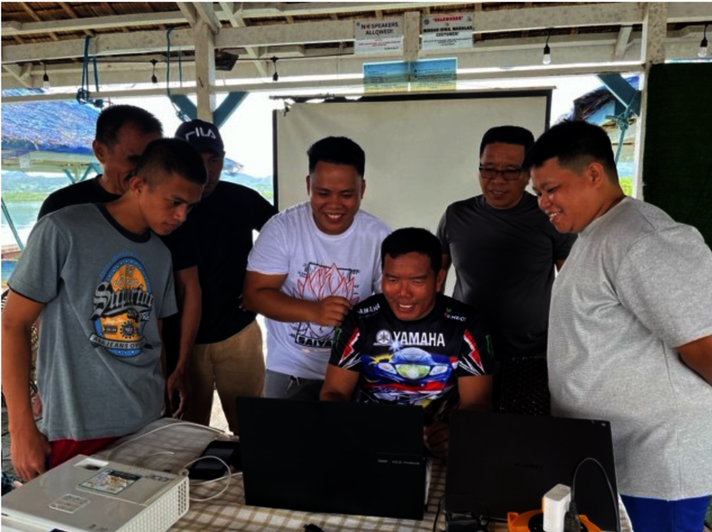
Building on the foundational knowledge gained from the workshops and the previously used pen-and-paper mangrove monitoring method, this second series of activities also introduced participants to essential digital applications designed to enhance field data collection and analysis. These included Geocamera, Geotracker, and most notably,Locus GIS—a mobile application that was subsequently used by communities during the actual field survey sessions.
A key highlight of this activity was thehands-on trainingprovided to participants, enabling them to independentlydownload, configure, and calibrateLocus GIS for local use. Communities utilized smartphones previously handed over in 2024, while others tested the apps on their devices, demonstrating both the practicality and accessibility of mobile-based monitoring tools. With the assistance of the facilitators, the community itself configured and calibrated the survey parameters necessary for field surveys. The real-time facilitated understanding and learning on how to use the app.
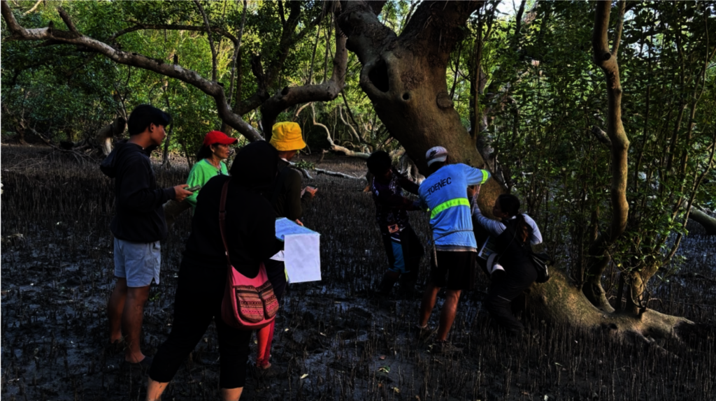
During the actual field survey sessions, participants were grouped in two (2) and were assigned specific survey areas. The same transect method from last year was used – 100-meter transect lines with sampling points every 20 meters. Each sampling point would collect data within a 5-meter radius. A hybrid approach emerges as a best practice – participants utilized both digital tools (Locus GIS and digital mangrove field guides) and manual methods (pen and paper survey and printed mangrove field guides). This proved to be invaluable. For instance, when the phone crashed during the field survey in Biliran, the participants were still able to continue the survey and collect data using the manual method.
Moreover, the field surveys were also designed and facilitated in such a way that communities would take the lead, with facilitators providing mentoring rather than direction. Notable best practices that were observed included: 1) clear communication and understanding of the survey methods and activities and, 2) assigning specific roles and responsibilities to group members, for example, one member focused on recording data parameters, while others identified mangrove species, took measurements, and so on.
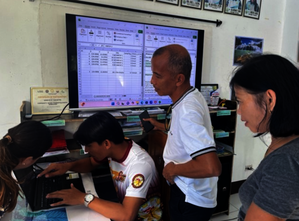
To supportdata management and sustainability, each community received alaptop, distributed during their respective survey sessions.
Dedicated learning activities that focused ondata transfer, processing, and cleaning were conducted. The participants primarily conducted these tasks with guidance from facilitators. Sessions covered key aspects such as importing data from mobile phones to laptops, data cleaning - reviewing species naming conventions, and ensuring consistency in measurement systems—laying the groundwork for quality assurance in community-led monitoring.
Communities were also introduced to theonline dashboard developed by Calibr8, a partner of AFIfor the Batangas Mangrove Sites. The online dashboard served as an inspirational example of how local data can be transformed into meaningful visualizations, opening up opportunities forfuture digital integrationand wider sharing of community-generated data.
Each site and community demonstrated distinct strengths and learning needs:
The foundation continues to work with our partner communities and champion experts in empowering these organizations in the protection of their natural resources and the development of their innate talents.
By TRISHA MANDAP | Resource Mobilization Officer
By Trisha Mandap | Resource Mobilization Officer
Project reports on GlobalGiving are posted directly to globalgiving.org by Project Leaders as they are completed, generally every 3-4 months. To protect the integrity of these documents, GlobalGiving does not alter them; therefore you may find some language or formatting issues.
If you donate to this project or have donated to this project, you can receive an email when this project posts a report. You can also subscribe for reports without donating.
Support this important cause by creating a personalized fundraising page.
Start a Fundraiser