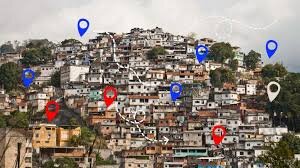
Home to 6 million people, Brazil's informal settlements (periferias) are among the most vulnerable to climate change and natural disasters-yet they remain largely unmapped. By equipping 200 trained community mappers with geospatial tools, HOT and partners will map 100 communities, generating critical data for climate adaptation, disaster preparedness, and sustainable planning. This data will help local and national authorities build long-lasting resilience, ensuring no community is left behind.
Brazil's informal settlements (periferias) are home to 6 million people, yet they remain unmapped, leaving residents exposed to climate risks, poor infrastructure, and inadequate disaster response. Without accurate data, local and national authorities struggle to plan for urbanization, climate adaptation, and emergency preparedness. Communities lack the tools to document risks like landslides and flooding, making it difficult to advocate for improvements and resources.
This project will map 100 informal settlements, collecting geospatial data on climate risks, infrastructure, and community resources. HOT and Mapa das Periferias will train 200 community mappers to use open-source tools, ensuring accurate data is created and used for urban planning and disaster preparedness. The data will support local and national authorities in making informed decisions, improving services, and strengthening climate resilience in periferias.
By creating detailed maps and training local mappers, this project will enable long-term improvements in urban planning, disaster response, and climate resilience for 6 million people in Brazil's periferias. Communities will have the data they need to advocate for better infrastructure and services, while authorities can make informed decisions to reduce risks. The open mapping network will continue beyond the project, ensuring sustainable data collection and community-driven solutions.